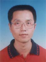
Liu Wanqing, born in 1965, graduated from the Department of geography in Shaanxi Normal University in 1987. In the same year, he continued reading regional geography postgraduates and graduated in June, 1990, obtaining the degree of Master of Science.
Liu has been working in the department of Remote Sensing and Geo-information Science in College of Urban and Environmental Science (formerly Department of Urban and Resource Sciences) Since June in 1990. Becoming an associate professor and a master tutor in 2000, he is mainly engaged in geography and geographical information system of professional teaching and research work and focuses on Digital Terrain Analysis and Loess Geomorphology.
Since 2000, he is mainly responsible for GIS undergraduate courses:" Cartography", "Digital Thematic Mapping"," Visual Program Design" as well as " Virtual Reality and 3D GIS" teaching tasks for undergraduate students and graduate students respectively. In recent year, 4 monographs and 23 research papers have been published.
RESEARCH GRANTS:
Department of education of Shaanxi Province, special research projects: Shaanxi National Scenic Area Tourism virtual three-dimensional visual system development, project number:02JK0852003-2005, host.
National Natural Science Fund Project: different physiognomy type areas of remote sensing image information capacity difference study, project approval No.: 410712712010-1012, ranked third.
city of Xi'an Research Projects Based on GIS network analysis of city public transportation intelligence assessment system study, project number:2008-2009, ranked 2.
Shaanxi Province Natural Science Fund Project: Land Use / land cover information extraction of remote sensing data and spatial scale effect research, project number:940052008-2009, ranked 3.
Department of education of Shaanxi Province, special research projects: the Loess Plateau Land Cover Information Extraction of remote sensing data and spatial scale effect research, project number:08JK4412008-2010, ranked second.
Department of education of Shaanxi Province, special research projects : the city fringe area dynamic monitoring of land use change in management information system development, project number:02JK0862003-2005, ranking: second.
Henry Fok fund, inhibit soil erosion on prevention of sandstorm role, item number:940052004-2007.3, ranking: second.
Department of education of Shaanxi Province, special research projects: monitoring of soil and Water Erosion Quantitative Terrain Factors index system and automatic extraction, item number:00JK1502001-2002, ranking: fourth.
Department of Education Science and technology research of major research projects: different spatial scale digital elevation model uncertainty analysis, item number:011112002-2004, ranking: fourth.
Teaching and Research Awards:
In February 2009," GIS college undergraduate professional plate type course system and teaching material construction for main course series" Northwestern University teaching achievement first prize. Ranking second.
In June 2009," GIS college undergraduate professional plate type course system and its main courses construction of" Shaanxi province teaching achievements second prize. Ranking second.
The June 2009 to October 2007 stage GIS professional guidance of Li Jingyi,4 students participated in the Ministry of Education organized the "First 2009’ GIS National Skills Competition", won the three step prize.
In December 2007, "Virtual Reality Geographic Environment" experimental teaching courseware development" from Northwestern University 2006 year experiment teaching project design, equipment development and courseware development fund outstanding project award.
Published books:
Tang Guoan, Zhao peony, Chen Zhengjiang, Liu Wanqing, etc.: "ArcView Geographic Information System Spatial Analysis Method", Beijing:Science Press, October 2002.
Liu Wanqing, Liu Yongmei, Yuan Kan: "Digital Thematic Graphics", Beijing:Science Press, September 2007.
Yuan Kansheng, Zhao Jun, Liu Wanqing, etc.: "Modern Cartography Course", Beijing: Science Press, December 2007.
Published papers:
[1] Liu Wanqing, Shi Yun, Liu Boli: 2006, The use of Imagis rapid making of city landscape 3D chart method -- Taking Northwestern University campus as an example, Journal of Northwestern University (NATURAL SCIENCE EDITION ), vol36(3):pp481-484.
[2] Liu Wanqing, Li Tianwen, Wang Xuhong, Long Yongqing: 2008, GIS university undergraduate curriculum system reform of advance gradually type research, HIGHER EDUCATION OF SCIENCES, vol2011(2):pp13-15.
[3] Liu Wanqing, Liu Yongmei, Yuan Kan, etc.: 2008, GIS university undergraduate cartography course plate optimization of teaching content, HIGHER EDUCATION OF SCIENCES, vol2008(3): pp58-61.
[4] Liu Wanqing, Chen Yunming, Zhang Chaochao: 2010, The Loess Plateau Based on DEM small watershed planning spatial data mining, bulletin of soil and water conservation, vol30(2):pp229-232.
[5] Wang Xuhong, Jia Baijun, Guo Jianming, Liu Wanqing, Li Hongmei: 2008, The SAM based remote sensing image classification technology research, Journal of Northwestern University (NATURAL SCIENCE EDITION), vol38(4): pp668-672.
[6] Wang Xuhong, Hu Ting, Jia Baijun, Liu Wanqing, Wang Lei, Qin Huijie: 2010, Based on geometric network analysis of the city public transportation intelligence evaluation. Application Research of computers, vol27(4): pp1397-1399.
[7] Tang Guoan, Liu Yongmei, Liu Wanqing, etc.: 2001, The Impact of Resolution on the Accuracy of Hydrological Data Derived from DEMs, Proceedings of the20th International Cartographic Conference (" GIS and Digital Mapping" essays ), 2001, pp1444-1453.
[8] Tang Guoan, Hui Yang River, Josef Strobl, Liu Wanqing: 2001, The impact of resolution: on the accuracy of hydrologic data derived from DEMs, the geographical journal, volume eleventh (English Edition ) . vol11(4), pp393-401.
[9] Shi Yun, Liu Wanqing: 2006, The quality of Ningxia tourism map compilation, Surveying and Mapping Science, vol30(1):pp84-86.


